Making Ranger Beads For Land Navigation
|
|
Materials Required
1. paracord 2. scissors 3. large needle 4. beads |
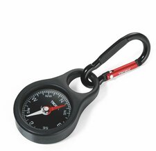
Problems with a Pocket Compass
|
In general they are not poorly accurate. And not so reliable in some cases. They may be used for generic direction of North and South, but the dangers of using a pocket compass is that you will have up to a ten degree span distance of error over great distances from that of your desired direction as the bearings are not precise.
In order to sidestep this some you will have to aim to the right or left of the object and use that as your bearing while leaving your true bearing to the left or right of this so that when you arrive toward that area you turn right or left to deliberately offset this. However, the further you are from your desired destination the more larger your aim must be to the right or left to keep from missing it. But mind you, these compasses where not designed to be precise measuring tools. |
LAND NAVIGATION COURSE:
Check out the first 2 lessons of our 7 lesson course in Land Navigation to get a taste of what's to come in the courses we are developing and other courses we will offer as well later. These courses are based around the layout and structure of Mors Kochanski's Grand Syllabus Instructor Trainee Program. We will soon in the near future begin offering courses on first aid, fire craft, shelters, cutting tools, setting up your personal gear, wild animal behavior, and much more. These courses are free for anyone who is interested in learning these skills, We are in the process of creating these courses and are excited about launching this soon so stay tuned!
|
Title: Lesson 1 The Compass
Description: 1-1. Understand the function of a Lensatic compass and its make up 1-2. Understand what is Magnetic North, and Grid North. 1-3. Understanding why we use the UTM (Universal Transverse Mercator Zone Chart) 1-4. Understand what is map scale is and why there is a difference in maps 1-5. Understanding the colors used on a map 1-6. Understanding a maps layout and structure 1-7. Understanding the declination chart 1-8. Understand when Magnetic North must be converted into Grid North 1-9. Understand how to orientate your compass to read Grid North
|
| ||
|
|
Title: Lesson 2 The Grid
Description: 2-1. Understand how to read grid coordinates 2-2. Understand what a 4 digit, 6 digit and 8 digit coordinate are 2-3. Understanding the difference between Magnetic North, True North and Grid North. 2-4. Understanding an azimuth 2-5. Understanding Terrain Features 2-6. Understand the difference between magnetic azimuth, and grid azimuth. 2-7. Understand how to plot a grid azimuth and know how to convert it into magnetic azimuth 2-8. Understand how to plot a magnetic azimuth
| ||
|
LESSON 3 - THE PACE COUNT (COMING SOON!!!)
Learning Objectives: 3-1. Determine your individual pace count 3-2 Determine your individual pace/stride 3-3. Identify what can affect your normal pace -Pace formula 3-4. Understanding the need for steering marks. -How bodies appear at ranges and different distances 3-5. Understand how to bypass obstacles. 3-6. Understand how to calculate time, distance, and rate
| |||
|
LESSON 4 - DETERMINING YOUR LOCATION
(COMING SOON!!!) Learning Objectives: 4-1. Understand how to locate your position when you have lost your orientation and how to find your location on a map using land feature identification. 4-2. Understand how to use a two point resections 4-3. Understand how to use a one-point resection, 4-4. Identify the five steps for navigating using terrain association 4-5. Understanding the term “dead reckoning” 4-6.. Identify how navigate using dead reckoning
| |||
|
LESSON 5 - NIGHT NAVIGATION (COMING SOON!!!)
Learning Objectives: 5-1. Understand how to use a compass at night. 5-2. Understand how to select the appropriate steering marks for navigating in the evening. 5-3. Understand how to properly choose which direction your bezel ring of your compass needs to and how many clicks are needed for the azimuth you have selected for evening travel. 5-4. Understand how to find true north. 5-5. Understand how to navigate at night using the stars. 5-6. Understand how to use the stars in order to dictate time. 5-7. Understand night time navigation issues, and how to avoid them. |
|
LESSON 6 - UNKNOWN TERRAIN (COMING SOON!!!)
Learning Objectives: 6-1. Understand how to create a self-mapped out area of your movement through the use of your pace-count, compass and other tools (a.k.a The PAUL method) 6-2. Learn how to explore about, yet maintain your current location as well as the whereabouts of unknown land markers and or land features 6-3. Understand how to triangulate a distance unknown and calculate the unknown distance. 6-4. Understand how to track your distance and always know your location using your pace-count and have an accurate azimuth without using a map. |
Land Navigation Course Material:
The Full course material coming soon! Our course material will be downloadable, free and will bring you an exhaustive learning manual that goes right along with the videos. We are working hard to get this finished so stay tuned for the link to be made available! Once all the videos are finished for each course we make the full downloadable version will available with all lessons put together.
Free Topographical Maps sites:

Make a free topographical map using Caltopo any where in the USA and customize it for your own needs as well. Click on the logo and it will take you directly to the website.
